Подводна ерупција на вулкан опкружен со мутирани ајкули

Lorita
By Lorita 2 Min Read
Disclosure: This website may contain affiliate links, which means I may earn a commission if you click on the link and make a purchase. I only recommend products or services that I personally use and believe will add value to my readers. Your support is appreciated!
- Solomon Islands, Solomon Islands -20220514- Kavachi Volcano in the Solomon Islands is one of the most active submarine volcanoes in the Pacific. According to the Smithsonian Global Volcanism Program, the volcano entered an eruptive phase in October 2021 and satellite data showed discolored water around Kavachi on several days in April and May 2022. These images, acquired on May 14, 2022, by NASA’s Operational Land Imager-2 (OLI-2) on Landsat 9 satellites, show a plume of discolored water being emitted from the submarine volcano, which lies about 24 kilometers (15 miles) south of Vangunu Island (shown below). Prior to this recent activity, large eruptions were observed at Kavachi in 2014 and 2007. The volcano erupts nearly continuously, and residents of nearby inhabitated islands often report visible steam and ash. The island is named for a sea god of the Gatokae and Vangunu peoples, and it is sometimes also referred to as Rejo te Kvachi, or “Kavachi’s Oven”. Since its first recorded eruption in 1939, Kavachi has created ephemeral islands on several occasions. But the islands, up to a kilometer long, have been eroded and washed away by wave action. The summit of the volcano is currently estimated to lie 20 meters (65 feet) below sea level; its base lies on the seafloor at a depth of 1.2 kilometers (0.75 miles). Kavachi formed in a tectonically active area—a subduction zone lies 30 kilometers (18 miles) to the southwest. The volcano produces lavas that range from basaltic, which is rich in magnesium and iron, to andesitic, which contains more silica. It is known for having phreatomagmatic eruptions in which the interaction of magma and water cause explosive eruptions that eject steam, ash, volcanic rock fragments, and incandescent bombs. -PICTURED: General View (Underwater Eruption In The Paciific Ocean) -,Image: 692334863, License: Rights-managed, Restrictions: , Model Release: no, Pictured: General View (Underwater Eruption In The Paciific Ocean), Credit line: NASA Earth Observatory images by Joshua Stevens/Cover Images/INSTARimages.com / INSTAR Images / Profimedia
- Advertisement -
Ad image

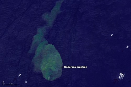
Сателитот на НАСА го сними моментот на ерупција на огромниот подводен вулкан Кавачи во длабочините на Тихиот Океан.

Ерупцијата беше снимена од НАСА со помош на Operational Land Imager, моќен телескоп лоциран на сателитот Landsat 8 во орбитата. Тоа е телескоп способен да прави детални фотографии од копно и море од вселената.

Сликата покажува голем облак од безбојна вода испуштена од потопен вулкан. Според вселенската агенција, тој бил присутен неколку дена помеѓу април и мај 2022 година.

Вулканот Кавачи беше добро истражен од научниците кои во 2015 година открија риби и ајкули кои ја населуваат областа околу вулканот, каде што киселата вода е топла, со значително ниво на сулфур. Водата содржи фрагменти од вулкански карпи и се верува дека ајкулите мутирале за да се прилагодат на екстремни услови.

„Во активниот кратер се забележани популации на желатинозни животни, мали риби и ајкули, што отвори нови прашања за екологијата на активните подморски вулкани и екстремните средини во кои може да постојат големи морски животни“, напишаа научниците тогаш.

Два вида ајкули, свилената ајкула и дива ајкула, беа снимени како пливаат во близина на вулканот за време на истражувачка посета.

Кавачи дури и го доби прекарот „Ајкула“ токму поради овие „жители“ кои живеат во такви екстремни услови.

Share This Article